WSentinel capture software creates 3 primary event files; composite jpg, video(.mp4), and a spreadsheet(.csv) which contains a timehistory of energy, azimuth/elevation, and pixel mapping for the event as seen from the camera location: (see Spreadsheet Column Definitions here).
NOTE: The az/el data in the spreadsheet are approximations and offline calibration is required for refined assessments. Refined calibrations require use of the nightly composites which are available via the link on the right side of this page.
If you don't see an event, or you are looking for data over 30 days old, please contact us at: 
Node Events (last 30 days)
|
|

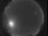
Date: November 3 2025
Time: 01:46:25.215 UTC
|

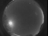
Date: November 3 2025
Time: 01:45:08.524 UTC
|

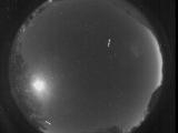
Date: November 3 2025
Time: 01:45:04.112 UTC
|

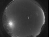
Date: November 3 2025
Time: 01:45:00.938 UTC
|
Date: November 3 2025
Time: 01:44:57.765 UTC
|

Date: November 3 2025
Time: 01:44:55.176 UTC
|

Date: November 3 2025
Time: 01:44:52.500 UTC
|

Date: November 3 2025
Time: 01:44:20.811 UTC
|

Date: November 3 2025
Time: 01:44:16.872 UTC
|

Date: November 3 2025
Time: 01:44:12.967 UTC
|

Date: November 3 2025
Time: 01:44:06.300 UTC
|

Date: November 3 2025
Time: 01:43:41.984 UTC
|
Date: November 3 2025
Time: 01:33:23.643 UTC
|

Date: November 3 2025
Time: 01:31:04.12 UTC
|
Date: November 3 2025
Time: 01:30:59.822 UTC
|

Date: November 3 2025
Time: 01:30:57.63 UTC
|

Date: November 3 2025
Time: 01:30:54.403 UTC
|
Date: November 3 2025
Time: 01:30:50.450 UTC
|

Date: November 3 2025
Time: 01:30:47.850 UTC
|

Date: November 3 2025
Time: 01:29:29.814 UTC
|
|
