WSentinel capture software creates 3 primary event files; composite jpg, video(.mp4), and a spreadsheet(.csv) which contains a timehistory of energy, azimuth/elevation, and pixel mapping for the event as seen from the camera location: (see Spreadsheet Column Definitions here).
NOTE: The az/el data in the spreadsheet are approximations and offline calibration is required for refined assessments. Refined calibrations require use of the nightly composites which are available via the link on the right side of this page.
If you don't see an event, or you are looking for data over 30 days old, please contact us at: 
Node Events (last 30 days)
|
|
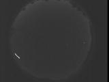
Date: September 2 2025
Time: 08:23:05.470 UTC
|

Date: September 2 2025
Time: 08:17:37.930 UTC
|
Date: September 2 2025
Time: 08:12:10.319 UTC
|
Date: September 2 2025
Time: 08:06:42.769 UTC
|

Date: September 2 2025
Time: 08:01:15.159 UTC
|

Date: September 2 2025
Time: 07:55:47.609 UTC
|

Date: September 2 2025
Time: 07:50:19.999 UTC
|

Date: September 2 2025
Time: 07:44:52.459 UTC
|

Date: September 2 2025
Time: 07:39:24.838 UTC
|

Date: September 2 2025
Time: 07:33:57.299 UTC
|
Date: September 2 2025
Time: 07:28:29.688 UTC
|

Date: September 2 2025
Time: 07:23:02.138 UTC
|

Date: September 2 2025
Time: 07:17:34.528 UTC
|

Date: September 2 2025
Time: 07:12:06.977 UTC
|

Date: September 2 2025
Time: 07:06:39.367 UTC
|

Date: September 2 2025
Time: 07:01:11.827 UTC
|
Date: September 2 2025
Time: 06:55:44.217 UTC
|
Date: September 2 2025
Time: 06:50:16.667 UTC
|

Date: September 2 2025
Time: 06:44:49.57 UTC
|

Date: September 2 2025
Time: 06:39:21.506 UTC
|
|
